Detailed Course Description
The Start is at the Lookout Campground, less than a mile west of Lookout Pass.
100-mile Course mileage
| Start (Lookout campground) | 0 |
| Government Creek | 8.5 |
| Simpson Springs Corral | 16.4 |
| Riverbed Station monument | 24.4 |
| Dugway Topaz Well | 33.3 |
| Dugway Pass | 37.5 |
| Dugway Geode Beds | 40.9 |
| Sweeping turn to north | 46.1 |
| Blackrock Station | 48.5 |
| Fish Springs | 58.2 |
| Blackrock Station | 67.9 |
| Sweeping turn to east | 70.3 |
| Dugway Geode Beds | 75.5 |
| Dugway Pass | 78.9 |
| Dugway Topaz Well | 83.1 |
| Riverbed Station monument | 92.0 |
| Simpson Springs Corral | 100.0 |
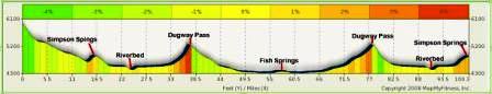
Elevation Profile
![]()
To get to the start:
From the Provo/Orem/Lehi area. (About 47 miles from Lehi, give yourself at least 1 hour 45 minutes.) From I-15, take Lehi Main Street Exit (motels) and head west on Main Street (State Road 73). Go all the way through Lehi, up Cedar Pass, through Cedar Fort, through Fairfield, to Five-mile Pass. At that point, take a left onto Faust Road. A sign marks the road indicating that it is the Pony Express Route. Continue west for about 13.7 miles until you come to a stop sign in Faust at Rt 36. Turn left, heading south on Rt. 36. After 0.6 mile, turn right on the Lookout Pass Road, heading west. It is also marked as the Old Pony Express Route. Go about 9 miles west up to Lookout Pass. Go over the pass and go about 0.8 mile further down to the Lookout Monument and Campground. This is the start area. The last two miles to the start are a graded 2WD dirt road.
From Salt Lake City. (About 70 miles from downtown, give yourself at least 2 hours). From I-15, Take I-80 heading west toward Tooele. Go about 20 miles. As you approach Tooele, take the exit for Rt. 36. Stay on Rt. 36 through Toole. You will be on Rt. 36 for about 39.3 miles. You will go through Tooele, Stockton, and Faust. After Faust, turn right on Lookout Pass Road, heading west. It is also marked as the Old Pony Express Route. (If you reach Vernon, you missed the turn). Go about 9 miles west up to Lookout Pass. Go over the pass and go about 0.8 mile further down to the Lookout Monument and Campground. This is the start area. The last two miles to the start are a graded 2WD dirt road.
Course Description
Start (0) to Simpson Springs Corral (16.4)
Head west down the road into Skull Valley. You are entering what was referred to as “Piute Hell.” Just stay on the main road that heads southwest. Follow signs that point to Simpson Springs or the Pony Express Trail. Keep your eye out for 4-foot cement posts on the left-hand side of the road that mark the actual Pony Express Trail. After about 5 miles along this road in the valley, it turns west at Government Creek (8.5). Porter Rockwell had his ranch here. In about four miles there will be an intersection, the main road continues south to Simpson Springs. You arrive at Simpson Springs (16.0) in 3.4 miles. The Pony Express station has been reconstructed here and there are bathrooms on the left. Continue running past the monument area and take a detour off the main road. Turn right and run down into the Corral area. Check-in with a timer here. This will also be the finish later on for the 100-mile race. Crews cannot follow their runner down the rough road to the Corral, but if they want to go to the Corral, they can continue down the main road and take the next right which will take them to the Corral.
Simpson Springs Corral (16.4) to Dugway Pass (37.5)
From Simpson Springs Corral, take the Corral road south back to the main road. The main road is Simpson Springs-Callao Road. It heads straight southwest — straight as can be. Keep your eye out for the skinny cement posts near the road every mile. Most of the posts near the road are very vandalized. After about 7 miles the road will descend down into an ancient riverbed. The Riverbed Station (24.4) is across the bottom on the north. The monument is off the main road a little bit. After another nine miles of straight road, you will come to an intersection at: N’39,53.069′ W113,01.768′. This is Dugway Topaz Well (33.3). There is a shack and a silo on the southeast side of this intersection. Keeping heading on the main road heading west. In the daylight, with a keen eye, you can look south and see the Dugway Station monument off in the desert (we won’t visit it, but your crew can if they want). Continue on climb up to Dugway Pass (37.5).
Dugway Pass (37.5) to Blackrock (48.5)
Go over the pass and head down into a beautiful valley. Just stay on the main road, heading west. You will pass by the turnoff for the Dugway Geode Beds (mile 40.9). At mile 46.1, the road will swing to the northwest and curve around a hill. You will come to the Black Rock Station (48.5). This will be the finish aid station for the 50-mile run, but 50-milers still have 1.5 more miles to run. They need to continue on the road for 0.75 mile to a turnaround point, put a sticker on their bib number, and come back to the finish. 100-milers continue on to Fish Springs.
Blackrock (48.5) to Fish Springs Headquarters (58.2)
100-milers continue on the main road toward Fish Springs National Wildlife Refuge. You should be able to see the structures or lights across the wide valley below. Our road does not go directly there, but makes a horseshoe to get around some of the marshes. About 3.2 miles from Blackrock, a road joins our road from the south. Stay right on the main road. Once down on valley floor, the main road will enter the Refuge and you will see a sign. THIS IS NOT THE TURNAROUND POINT! You still have about 4 more miles to go. If you don’t see buildings and lights next to you, you aren’t there yet. The road continues west through the refuge and comes to a T with Sand Pass Road coming from the south. You want to take a right, staying on the main road. Continue heading north for about 1.3 miles to the Fish Springs Headquarters entrance and sign. Go right into the headquarters. The turnaround is at the Kiosk area. There are public restrooms and a pay phone here. Crews might consider showing up here early to drive part of the Fish Springs auto tour.
Fish Springs Headquarters (58.2) to Simpson Springs Corral (100.0)
To reach the finish, simply go back the way you came all the way back to Simpson Springs. As you approach Simpson Springs, you will take a left-hand turn to head another 0.6 mile to the Corral and the finish.


Comments
Trackback